Earth observation and remote sensing
SAR
What is SAR?
SAR is a synthetic aperture radar that operates in a band of the spectrum between 1 mm and 1 m. It sends electromagnetic pulses to the earth with the aim of recording their return once reflected by the surface and thus obtain images of the illuminated area, in a different way than that used in multispectral products (Vegetation indices (NDVI, NDRE, NDWI) or RGB images).

Another major difference is the type of sensor. The multispectral sensors used detect radiation emitted or reflected from natural bodies. SAR is an active sensor, so it does not need other sources of illumination, as is the case with optical sensors that need solar energy. Therefore, the first significant characteristic of a SAR is that it can operate both day and night.
On the other hand, the signals used by these radars are in the microwave band of the electromagnetic spectrum, signals at these frequencies are affected in a limited way by atmospheric humidity and cloud cover conditions, therefore, clouds and rain can be considered largely transparent to radar.
Polarization
The direction of electromagnetic wave propagation is defined as wave polarization. These can be horizontal and vertical.

When the transmitted energy is polarized in the same direction as the received energy, the system is known as similar polarization.
HH indicates that the energy is transmitted and received horizontally polarized;
VV means that energy is transmitted and received vertically polarized.
VH polarized combination.

The reflection of a radar wave when hitting a surface can modify the polarization, depending on the properties of the surface itself.

Advantages and Disadvantages
What advantages can SAR offer us?
• Function under almost any weather condition • Observe the Earth’s surface during day or night • Penetrate vegetation • Penetrate soils • Atmospheric effects are minimal • Sensitive to dielectric properties of the surface (e.g. Frozen vs thawed water) • Sensitive to the structure of surface components
Disadvantages
• The information is different from optical images and can be difficult to interpret.
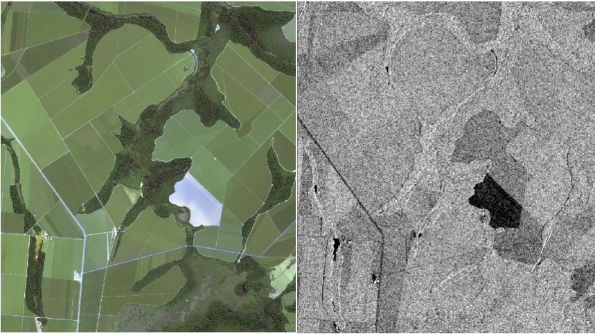
Left multispectral; right radar
• Presence of noise (salt and pepper effect in images). • Distortions in areas with abrupt topography • Torrential rains at the time of acquisition can cause alterations in the result. • In pivot irrigation areas, alterations can occur if the pivots are operating at the time of pass-over.
SAR in agriculture
SARs respond to (basically) two fundamental characteristics of an agricultural target: structure (biomass quantity, plowing, harvesting) and moisture. This is why HEMAV is working on the following radar applications:
Sowing: Coherence: Location of sowing and detection of growth rate before becoming visible with multispectral sensor.
Crop monitoring: Amplitude: With amplitude we can determine the growth rate of different fields.
Humidity control: Soil moisture calculation to monitor the crop’s water status.
Harvest: Drying monitoring to determine harvest zones.
Information Sources
Sentinel 1
All these work applications are possible thanks to the SENTINEL 1 constellation, which feeds us and provides different radar images for the fields of study.
The periodicity of radar data collection can vary depending on the region of the world being analyzed. The usual range varies from 2 to 3 days up to a maximum of 12 days
In the following photo, the frequency is shown according to the geographical area.
